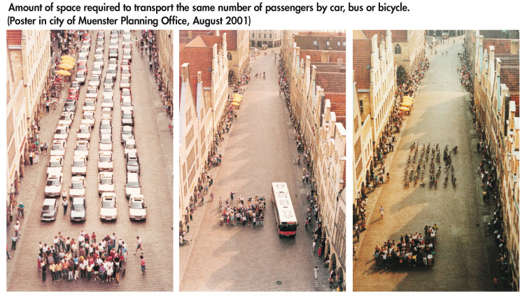
Please consider the graphic above as you consider voting for Measure J. You can read the LA Times endorsement here, which said that "extending the tax increase approved by voters in 2008 would be a win for transit, the economy and the future of L.A. County." You can also read more about Measure J from Metro below:
October 17, 2012
Measure J
The Presidential debates are raging and election season is in full swing. According to some recent poll of polls, the race between Obama and Romney is a statistical dead heat. As exciting as that is, don't forget about your local issues. One of of the most important and long-lasting is Measure J. According to Metro, Measure J will "extend an existing voter approved half-cent transportation sales tax, until 2069, in order to accelerate the construction of regional traffic relieving highway and transit projects. The measure will also provide 30 additional years of funding for local transportation improvements and operation of regional transit services."
October 15, 2012
Parking Garage Photo Essay
 |
| Cincinnati, Ohio |
From Atlantic Cities: Parking structures "are increasingly seen as opportunities for mixed uses and attractive design as cities become more aware of the bad impression they can leave on the sidewalk and the skyline.
 |
| Malmo, Sweden |
Outside of Miami, most cities are less inclined to see their parking garages as opportunities for starchitect-driven visions, but still see them as opportunities for design." There are some interesting photos from the US and Europe. See the other 13 garages here.
 |
| Utrecht, Netherlands |
October 12, 2012
Carbon Emissions Map for Los Angeles
It's hard to reduce carbon dioxide emissions when you're not sure where they're coming from. This new map from The Hestia Project shows the exact source of carbon dioxide emissions throughout Southern California. Freeways are the most obvious feature, which are clearly present in the ribbons of red that criss-cross the region. The density of the westside and hollywood area is also clearly delineated on the map.
The "Carbon Emissions by Sectors" key is hard to read and major regional polluters, like the Port complex in Long Beach, do not appear on the map as clearly as they routinely do in statistical calculations about regional pollution.
The "Carbon Emissions by Sectors" key is hard to read and major regional polluters, like the Port complex in Long Beach, do not appear on the map as clearly as they routinely do in statistical calculations about regional pollution.
August 22, 2012
Go Solar Today
There are three indisputable facts about the world today: Energy prices are rising; Our fossil fuel resources are finite and dwindling; and Traditional energy production is degrading our environment.
Now is not the time to double down on dirty and increasingly expensive fossil fuels. Now is the time to invest in alternative energy sources that: Protect consumers from increases in energy prices; Are infinitely renewable and readily available; and Good for the environment and good for our economy.
You can read more about my solar installation business and thoughts on solar in this American News Report article, "Renewable Solar Energy Looking For A Foothold."
April 6, 2012
Transit-Shed by Neighborhood
Combining mass transit and biking data, Mapnificient creates an interactive google map overlay of Los Angeles to display how far you can travel without a car during a certain time frame. Depending on the time of day and how long you're willing to travel, i.e. 15 minutes or 30 minutes, it creates an interesting visual illustration of what I call your transit-shed - the distance one can travel in a given amount of time by mass transit. Since Mapnificient layers its information (taken from Metro Trip Planner) on top of a google map, you can search for things like "ice cream" to see how accessible certain attractions are without a car.
Drag the pin around and adjust the time cursor to test your transit-shed. Maybe you could increase your transit mobility if you moved to another neighborhood? This tool allows you to test those hypotheses. Try it out.
 |
| Sunset Junction |
 |
| Warner Center Orange Line Terminus |
January 18, 2012
Not Enough Trees
 |
| Source: la.curbed.com |
When thinking about the impact trees have on urban and global sustainability, consider a few of the highlights from TreePeople's "Top 22 Benefits of Trees."
- Trees absorb odors and pollutant gases and filter particulates out of the air by trapping them on their leaves and bark.
- In one year an acre of mature trees can provide enough oxygen for 18 people.
- Trees cool the city by up to 10°F, by shading our homes and streets, breaking up urban “heat islands” and releasing water vapor into the air through their leaves.
- Three trees placed strategically around a single-family home can cut summer air conditioning needs by up to 50 percent.
- Shade from trees slows water evaporation from thirsty lawns. Most newly planted trees need only fifteen gallons of water a week.
- Trees reduce runoff by breaking rainfall thus allowing the water to flow down the trunk and into the earth below the tree, which prevents stormwater from carrying pollutants to the ocean.
- Tree prevent soil erosion by slowing runoff and holding soil in place.
- Trees reduce UV-B exposure by about 50 percent
- An apple tree can yield up to 15-20 bushels of fruit per year and can be planted on the tiniest urban lot.
Subscribe to:
Posts (Atom)

