July 18, 2013

"They Paved Paradise and Put up a Parking Lot"

In a recent editorial for the Architect's Newspaper, Sam Lubbel believes Los Angeles must find new uses for underused spaces: "As our urban fabric moves into the 21st century, we need to rethink our infrastructure in serious, holistic ways. While we’re stuck resorting to parking lot cultural space there’s so much wasted infrastructure that could be transformed into something better." Forced into existence by excessive minimum parking standards, the ever ubiquitous surface parking lot is now providing a tabula rasa for experimental architecture and cultural installations in most major cities throughout the US, not just Los Angeles. For proof, just look at the explosion of "park-lets" and popularity of "Park(ing) Day."
Source: Architect's Newspaper
Lubbel also provides the framework for rethinking our infrastructure in more holistic ways and makes some provocative suggestions that go beyond just parking lots: "Outside of turning parking lots into parks, why can’t the concrete-lined LA River become a place to show off art? How about the subway? Couldn’t that be a place for artists and architects to show off their stuff in a much more profound way than it usually is? Have you ever seen the amazing subway stations in Stockholm? You should take a look. And why do the spaces under freeways need to be vacant concrete zones? In Mexico City, for instance, they’re the spaces for parks. Smart infrastructure planning goes a long way. Then of course there’s the most famous example: re-using an abandoned train line to become the High Line in New York."

April 2, 2013

Los Angeles Electricity Use

Check out this incredible map showing electricity use by block group. The data is very fine grain and can even be manipulated to show change over time and monthly consumption. I could imagine this is particularly helpful for solar companies, like SunCraftsmen Solar, looking to find potential customers. Use the map here.

April 1, 2013

Smog Eating Buildings

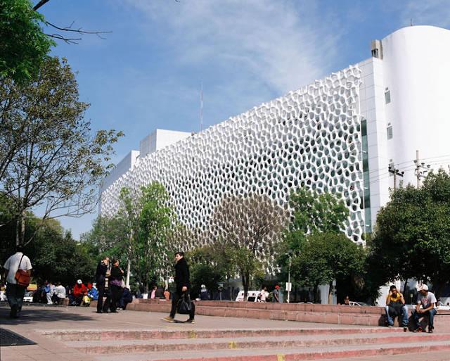
Reducing point source emissions is a necessary first step in the fight against climate change and air pollution. Finding ways to merge science + architecture to create innovative solutions that reduce air pollution by design takes things one step further. It would be great to see Los Angeles, still ranked among the worst air quality in the US, build smog eating buildings like the one shown below in Mexico City. In fact, the new Broad Museum on Grand Avenue, with its honeycomb exterior facade, would be a perfect candidate for this sort of technology.
Fast Company describes the chemical process: "When UV light cuts through smoggy air and hits the titanium dioxide on the tiles, a chemical reaction occurs between the tiles and chemicals in the smog--mono-nitrogen oxides, or NOx. A lot of chemistry goes on in the interim, but for simplicity’s sake, the end result of the reaction is that the smog is broken down into small amounts of less noxious chemicals, including calcium nitrate (a salt used in fertilizers), carbon dioxide, and water. The titanium dioxide itself remains unaffected, so it can keep making reactions happen."

February 7, 2013

Parklets in Los Angeles

Source: Architect's Newspaper. One of two new parklets on Spring St. in DTLA.
Multiple news sources have reported on the opening of LA's first "parklet" last week. Here is a clip from The Architect's Newspaper: "On February 3, Los Angeles kicked off its pilot parklets program, announced last fall, with the opening of a miniature public space in Eagle Rock, a neighborhood in East Los Angeles. Designed by LA landscape architecture firm Shared Spaces, the park is located on the site of a former illegal parking space in front of Bobby’s Auto Parts near the corner of Avenue 50 and York Boulevard." You can find the rest of the article here.
Source: Architect's Newspaper. The other parklet on Spring St.

October 17, 2012

Measure J

The Presidential debates are raging and election season is in full swing. According to some recent poll of polls, the race between Obama and Romney is a statistical dead heat. As exciting as that is, don't forget about your local issues. One of of the most important and long-lasting is Measure J. According to Metro, Measure J will "extend an existing voter approved half-cent transportation sales tax, until 2069, in order to accelerate the construction of regional traffic relieving highway and transit projects. The measure will also provide 30 additional years of funding for local transportation improvements and operation of regional transit services."


Please consider the graphic above as you consider voting for Measure J. You can read the LA Times endorsement here, which said that "extending the tax increase approved by voters in 2008 would be a win for transit, the economy and the future of L.A. County." You can also read more about Measure J from Metro below:

What is Measure J?

Measure J will extend for 30 additional years the existing one-half cent sales tax that was approved in 2008 (Measure R) and is currently set to expire in 2039. The additional funds will be used to sell bonds, which will allow Metro to accelerate construction of transportation improvements. According to a 2008 study by the private non-profit Los Angeles County Economic Development Corporation (LAEDC), the current tax costs residents an average of $25 per person per year. Because Measure J will extend the existing sales tax, it is anticipated the costs will remain the same, adjusted for inflation. Tourists and businesses also contribute money through the sales tax. The measure also allows transit and highway funding priorities to be shifted between projects within subregions of Los Angeles County, if approved by a two-thirds vote of the Metro Board.

Regional Impact

LAEDC reports that the projects accelerated through Measure J will advance the creation of 250,000 new local jobs (direct, indirect and induced workers). By starting construction on seven rail and rapid transit projects, and up to eight highway projects within the next five years, instead of the twenty years currently planned, this job creation will be accelerated. The measure will also provide an additional thirty years of continued funding for local transportation improvements (ex. pothole repair, signal synchronization, local roadway and bridge safety improvements), countywide bus and rail service operations, Metrolink and Metro Rail capital improvements, and administration. The LAEDC projects that these activities will generate another 220,000 direct, indirect and induced jobs in addition to the employment advanced by the transit and highway project acceleration noted above.

Taxpayer Oversight

Under the existing measure, there is an annual independent audit and report to taxpayers, and ongoing monitoring and review of spending by the independent taxpayer oversight committee. The reports are available for public review on the internet and in public libraries. This oversight will continue with Measure J.

October 15, 2012

Parking Garage Photo Essay

Cincinnati, Ohio
From Atlantic Cities: Parking structures "are increasingly seen as opportunities for mixed uses and attractive design as cities become more aware of the bad impression they can leave on the sidewalk and the skyline.
Malmo, Sweden
Outside of Miami, most cities are less inclined to see their parking garages as opportunities for starchitect-driven visions, but still see them as opportunities for design." There are some interesting photos from the US and Europe. See the other 13 garages here.
Utrecht, Netherlands

October 12, 2012

Carbon Emissions Map for Los Angeles

It's hard to reduce carbon dioxide emissions when you're not sure where they're coming from. This new map from The Hestia Project shows the exact source of carbon dioxide emissions throughout Southern California. Freeways are the most obvious feature, which are clearly present in the ribbons of red that criss-cross the region. The density of the westside and hollywood area is also clearly delineated on the map.
The "Carbon Emissions by Sectors" key is hard to read and major regional polluters, like the Port complex in Long Beach, do not appear on the map as clearly as they routinely do in statistical calculations about regional pollution.

August 22, 2012

Go Solar Today

There are three indisputable facts about the world today: Energy prices are rising; Our fossil fuel resources are finite and dwindling; and Traditional energy production is degrading our environment.

Now is not the time to double down on dirty and increasingly expensive fossil fuels. Now is the time to invest in alternative energy sources that: Protect consumers from increases in energy prices; Are infinitely renewable and readily available; and Good for the environment and good for our economy.

You can read more about my solar installation business and thoughts on solar in this American News Report article, "Renewable Solar Energy Looking For A Foothold."

April 6, 2012

Transit-Shed by Neighborhood

Combining mass transit and biking data, Mapnificient creates an interactive google map overlay of Los Angeles to display how far you can travel without a car during a certain time frame. Depending on the time of day and how long you're willing to travel, i.e. 15 minutes or 30 minutes, it creates an interesting visual illustration of what I call your transit-shed - the distance one can travel in a given amount of time by mass transit. Since Mapnificient layers its information (taken from Metro Trip Planner) on top of a google map, you can search for things like "ice cream" to see how accessible certain attractions are without a car.
Sunset Junction
Drag the pin around and adjust the time cursor to test your transit-shed. Maybe you could increase your transit mobility if you moved to another neighborhood? This tool allows you to test those hypotheses. Try it out.
Warner Center Orange Line Terminus

January 18, 2012

Not Enough Trees

Source: la.curbed.com
Los Angeles is 21% covered by tree canopy, according to the Million Trees LA initiative, a fact confirmed by a recent study from the Woods Hole Research Center. This doesn't even compare to the national average of 27% and is even less impressive considering the region's temperate climate and decentralized pattern of urbanization.

When thinking about the impact trees have on urban and global sustainability, consider a few of the highlights from TreePeople's "Top 22 Benefits of Trees."

  • Trees absorb odors and pollutant gases and filter particulates out of the air by trapping them on their leaves and bark.
  • In one year an acre of mature trees can provide enough oxygen for 18 people.
  • Trees cool the city by up to 10°F, by shading our homes and streets, breaking up urban “heat islands” and releasing water vapor into the air through their leaves.
  • Three trees placed strategically around a single-family home can cut summer air conditioning needs by up to 50 percent.
  • Shade from trees slows water evaporation from thirsty lawns. Most newly planted trees need only fifteen gallons of water a week.
  • Trees reduce runoff by breaking rainfall thus allowing the water to flow down the trunk and into the earth below the tree, which prevents stormwater from carrying pollutants to the ocean.
  • Tree prevent soil erosion by slowing runoff and holding soil in place.
  • Trees reduce UV-B exposure by about 50 percent
  • An apple tree can yield up to 15-20 bushels of fruit per year and can be planted on the tiniest urban lot.

December 16, 2011

1959 ULI Film on Urban Sprawl

It's interesting to see how our understanding of "efficient use of land" has changed over the last 50 years. The video, in many ways, is incredibly prescient in its diagnosis of the causes and effects of unchecked urban sprawl. Its ideas, however, for curing these problems seem somewhat antiquated and have become problems themselves, like the overuse of cul-de-sacs in planned unit developments. Either way, it's an interesting historical planning document that's worth watching.

October 3, 2011

Next CicLAvia - Sunday October 9, 2011

With new north and south spurs, the next CicLAvia is scheduled from 10am to 3pm this Sunday, Oct. 9. Come join us and explore the recreational, cultural and social possibilities when ten miles of city streets are closed temporarily to car traffic.
Source: CicLAvia.org

September 28, 2011

Times Critic Reviews New West Hollywood Library

Los Angeles Times architecture critic, Christopher Hawthorne, recently reviewed the new West Hollywood Library, which also contains new chambers and meeting space for the West Hollywood City Council. Hawthorne' full review can be read here.
Source: Los Angeles Times
Hawthorne begins his review with a decidedly positive summary: "The new West Hollywood Library, set to open to the public Saturday on a curving stretch of San Vicente Boulevard across from the Pacific Design Center, is a building that offers a freewheeling tour through centuries of architectural history. Explicitly or implicitly, it points back to the work of Charles Moore, Pierre Koenig, Frank Gehry and even Michelangelo...Whatever you want to call its style (the first local stirrings of a postmodern revival, maybe?), it sounds altogether too busy and too stuffed with architectural influences to succeed. And yet it does succeed — beautifully."
Source: Los Angeles Times
Rarely does Hawthorne offer such a glowing review of public works projects. He concludes his review with a poignant observation that resonates well beyond the walls of West Hollywood's newest civic achievement: "But after many decades of existing as an essentially privatized metropolis — with mostly residential architectural landmarks to match — our region is being forced, as it grows denser, to relearn the art of civic architecture and to reengage the public realm. And in that sense the library is a tremendously encouraging achievement."

August 30, 2011

1928 Los Angeles Transit Map

Check out this transit map from 1928, twelve years before the Arroyo Seco Parkway opened as the first freeway in the region. It's interesting to see Los Angeles devoid of freeways - they are the physical markers that shape the contours of many of the city's neighborhoods, determine our common understanding of place, and orient our conception of the region's geography. Take some time to study the map and try to understand the city without the mental markers provided by today's freeways.
Map scan source: David Rumsey Map Collection
You can read more about the map and its similarities to existing bus lines at Metro's blog, The Source.

August 29, 2011

Explore the 2010 Census

Use CNN's new interactive map to track demographic and population changes over the past ten years. These statistics are culled from the most recent 2010 census. It is interesting to alter the scale (census tract, county, state) when selecting from the pull down menu of population and demographic categories.
Source: CNN.com
Notice that when you select "population density" by "census tract" it becomes very clear that the densest and most populated parts of our country are concentrated exclusively in metropolitan regions, with Los Angeles being one of the largest (below).
Source: CNN.com

August 22, 2011

Urbanology from the BMW Guggenheim Lab

TheCityFix announced recently, "the BMW Guggenheim Lab released an online urban planning game, “Urbanology,” as a platform to explore urban issues...Each player assumes the role of a decision maker and answers questions to determine the priorities of a fictitious city. By answering “yes” or “no” to questions like, “Will you double the cost of public transport to fund its conversion to a carbon-neutral system?” or “Will you pay for a free bike service in your city?” players build a city that best matches their urban ideology."

The article goes on to describe the game's creator, the BMW Guggenheim Lab, as a "mobile laboratory that will travel to nine major cities worldwide over a six-year period to address issues of contemporary urban life through programs and public discourse. The lab is an international group of urban planners, architects, artists, designers, scientists, as well as experts in technology, education and sustainability who explore new ideas, experiment and create forward-thinking solutions to the challenges of urban life.

The lab functions partly as an urban think tank and partly as a community center, initiating public discussion on issues that affect livability, sustainability, public health and transportation in cities. Urbanology is an online extension of the physical installation and the theoretical discussion. In addition to answering questions, players can also suggest additional questions, which can serve as a global exchange of ideas and lead the discussion on urban issues."

Though Urbanology is an interesting thought experiment for those willing to test their personal beliefs against some of today's most pressing urban issues, TheCityFix correctly points out that "it also oversimplifies the decision-making process and provides too little context for the fictitious city. For example, deciding to put affordable housing in a vacant lot over a five-star hotel may increase a city’s affordability for its citizens but decrease lifestyle points, making your city less attractive to tourists. Making such abstract decisions without having the necessary context, like knowing the average household income or demographics, may have the opposite of the desired outcome for your fictitious city."

You can play the game here and decide for yourself. For what it's worth, my city is Singapore. 

August 1, 2011

1906 Los Angeles Transit Map

Here is another interesting post from the Big Map Blog. Notice how many of today's transit lines trace routes used over 100 years ago (Blue, Expo and Gold Lines). This is due to the fact that many of the city's old rail right-of-ways were never developed nor put to any other use after they were decommissioned.

July 25, 2011

Walk Score for 95 LA Neighborhoods

Though not necessarily the best or only metric for determining walkability, Walk Score is still a fairly useful guide for comparing different neighborhoods and understanding the relationship between amenities (shops, restaurants, grocery stores, etc.), public transit accessibility and other computable factors that determine walkability. You can read about Walk Score's methodology here.

Walk Score released its most recent rankings for "Los Angeles' Most Walkable Neighborhoods." Click on the link for the full list and to see your neighborhood ranking.

Source: Walk Score

June 27, 2011

Water Wise House in Mt. Washington

Mt. Washington Home. Source: LA Times
"Those who follow sustainable design say the new residence could very well be one of the most water-efficient houses in the region, a milestone for L.A. as the city seeks better models of conservation. The Nob Hill Haus, as its owner-designers call it, could serve as a template for the house of the future here." (Click here for a link to the full LA Times story.)
Laundry, bath, and sink water flows into this tank before traveling through perforated underground pipes that feed plants. Source LA Times
Partners Frank Pasker and Grit Leipert "let California's scarcity of two resources — power and water — shape the design philosophy for" their new 2,400 square foot Mt. Washington home, which is designed to reduce energy and water consumption to the greatest extent possible. The couple's ultimate goal is to make it a net-zero energy home.

The Los Angeles region is poised to grow considerably over the next couple decades and a similar "design philosophy" is needed for the region to grow sustainably. Climate scientists predict drier and shorter Sierra winters, which means less water for Southern California. As Pasker points out, "California challenges you to do something because of the climate...You want to work with the climate, not against it." Working with the climate, with a particular focus on energy and water, will become the hallmark of successful sustainable design and help shape the future of development in Southern California.
Composting Bins. Souce: LA Times

Green Credentials:
  • Gravity fed grey water system with no pumps, filters or electrical devices
  • Grey water system treats 160 gallons of water per day, which then waters the yard through a series of underground perforated pipes
  • 1,500 gallon cistern used to capture rainwater and water backyard plants
  • 50% water use reduction from the typical Los Angeles home
  • 120 gallon roof-mounted solar water heater
  • 50% thicker walls than required to reduce heating/cooling needs
  • 3.2 kilowatt solar array designed to offset any electricity use

1,500 gallon cistern, which holds captured rainwater for plant watering. Source LA Times

June 16, 2011

Transit Adjacent Markets

Here's a new form of transit-oriented development: Transit Adjacent Markets. The most interesting aspect of this clip is the efficient use of space, common sense understanding of public safety, and informal use of land. The speed with which the life and urban atmosphere of the market is dismantled and reconstructed is impressive and makes one realize that cities often do not need complex and expensive investments to breath life into formerly neglected spaces.